- Ships DX
- Smart Ship Initiatives

 What is ClassNK Innovation Endorsement?
It is a system where ClassNK, an independent third-party organization, certifies and issues certificates for innovative functions, thereby supporting the deployment of products and services. J-Marine Cloud underwent detailed verification and examination, and obtained this endorsement.
New Feature Highlights
In April 2026, a GNSS spoofing/jamming display function linked with the onboard GNSS device "JLR-41" was added to SSV. This function receives and displays the results obtained from the spoofing/jamming countermeasure function of the JLR-41 on the SSV side, allowing users to check both the current occurrence status and past occurrence history. This intuitively visualizes the locations where position information loss has occurred and its causes, providing strong support for understanding the impact of GNSS interference and improving navigation safety.
Status Display on Ship List
When spoofing or jamming is detected on a vessel equipped with JLR-41, a badge is displayed on the corresponding ship in SSV's Ship List, enabling immediate identification of anomalies.
This allows fleet managers overseeing many vessels to quickly identify affected ships.
GNSS Interference Information Tab Added to Conning Display
The screen allows visual confirmation of statuses such as Jamming L1, Jamming GLONASS, Jamming BDS, and Spoofing detection, enabling operators to understand which satellite systems are affecting the vessel during navigation.
Highlighted Display of spoofing/jamming Occurrence Segments on Track
Tracks where spoofing/jamming occurred are highlighted on SSV.
Relevant segments can be displayed going back up to 60 days, making it useful for post-incident verification, trend analysis of hazardous waters, and information sharing among stakeholders.
VDR Data Playback
This feature enables remote downloading of ship's VDR data through SSV and playback on the SSV platform. It allows for verification of the ship's navigation status and facilitates situation assessment without placing an additional burden on the crew in the event of a maritime accident. This capability ensures accurate determination of the cause.
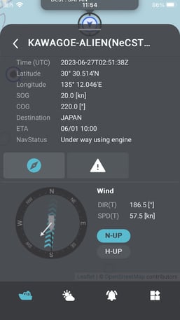
Dashboard
This feature enables the display of navigation status and alarm occurrences of multiple managed ships on a single monitor, facilitating quick identification of ships that require attention.
Mobile Application "Sail Assist"
We have developed a new smartphone application that can be linked with SSV for use on ships. In addition to viewing ship information, the application provides support services such as fuel switching assistance, aiming to enhance operational efficiency through user-friendly functionalities.
New Features in Smart Ship Viewer
- Two-Factor Authentication
- New GUI
- Dashboard
- Alert History
- Navigation Warnings
- Weather Monitoring
- VDR Data Playback
- Cloud Data Playback
- Emergency (Linkage with J-Marine NeCST is necessary)
- ECA *2 Display
- Fuel Switching Task Completion History
- Chat Communication (SSV Mobile)
Sail Assist Application
- ECA Display
- Fuel Switching Support
- NGA*3notification
- Notification & Display of Alert History
- Chat Communication
- Marine Equipment Manual Viewer
*2: ECA=Emission Control Area
*3: NGA=No Go Area
Features
Feature List
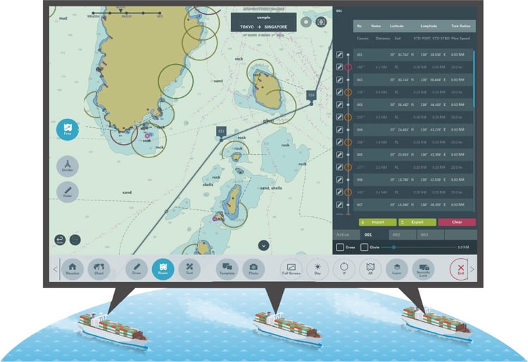
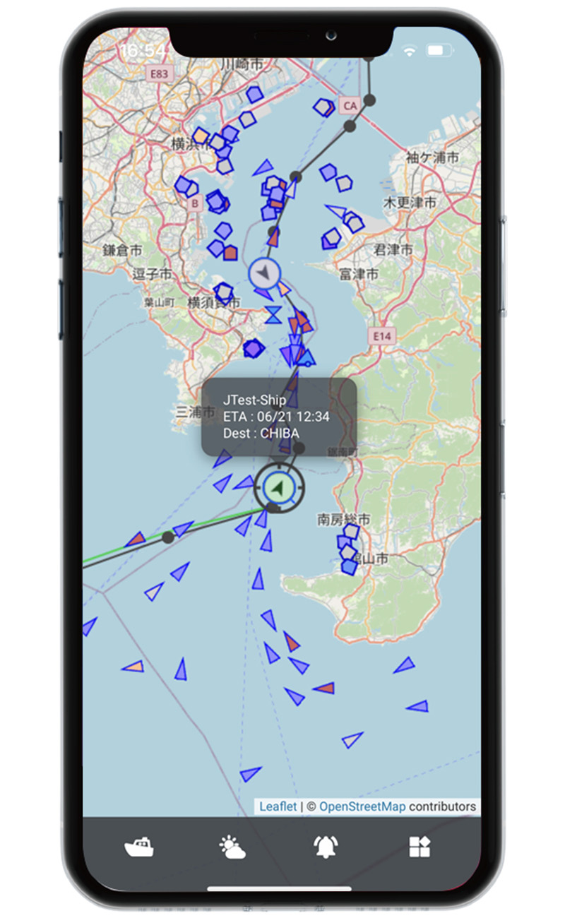
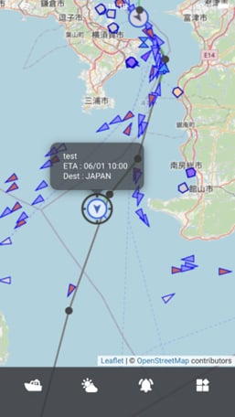
Ship Monitoring Service
Monitor the Status of the Managed Vessel at Sea From the Office
This service*1 allows you to monitor the status of managed ships and condition of our onboard equipment via a web browser while at the office of your company.
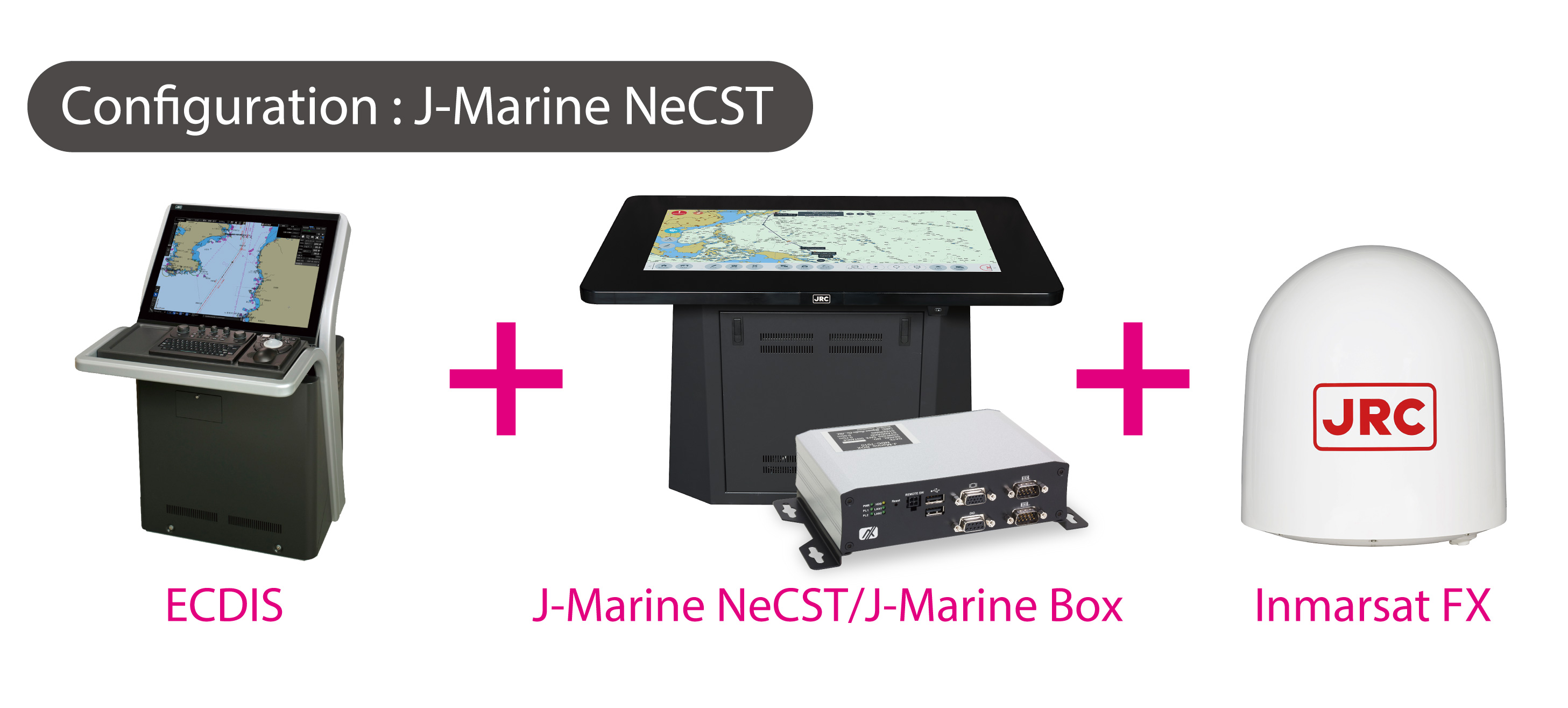
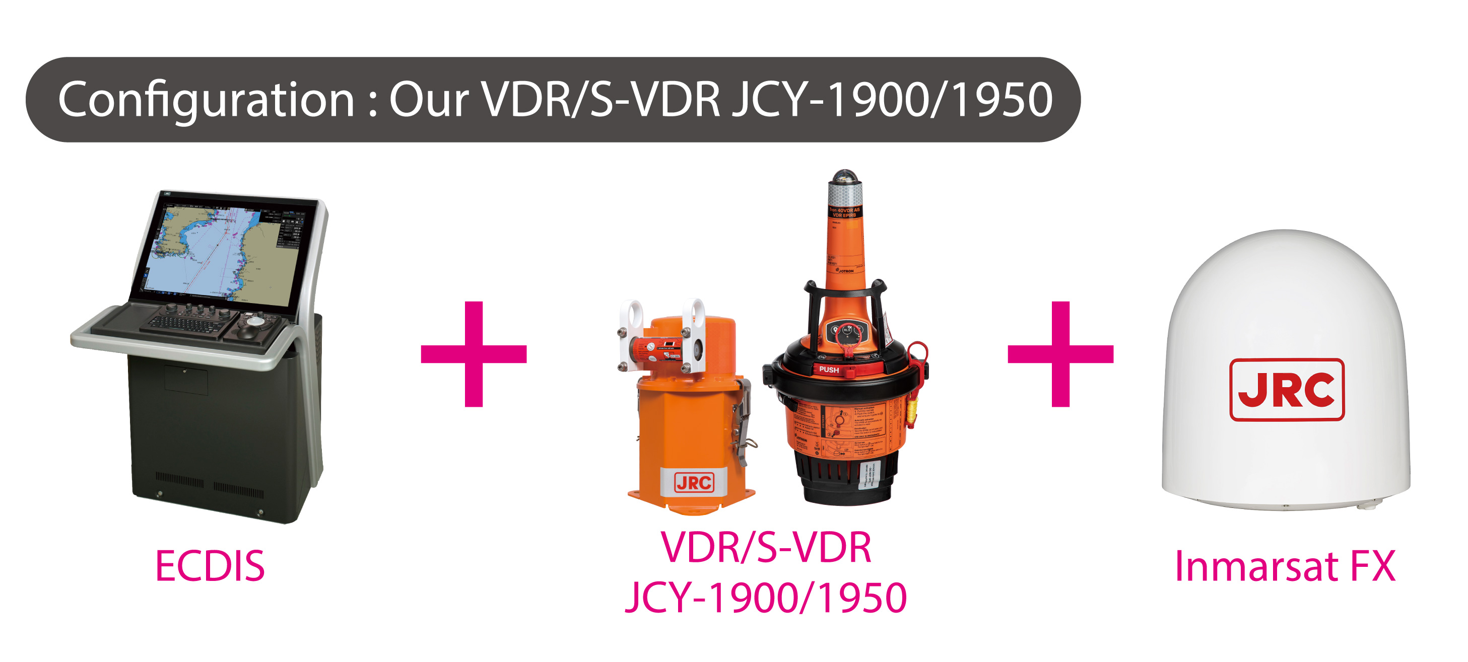
The recommended configuration for this service is a combination of our VDR/S-VDR and J-Marine NeCST, but partial services can be provided with only our VDR/S-VDR JCY-1900/1950, J-Marine NeCST, or J-Marine BOX.
*1 : This service requires installation of Inmarsat FleetXpress or VSAT. The information that can be monitored varies depending on the installed equipment.
Screen Example
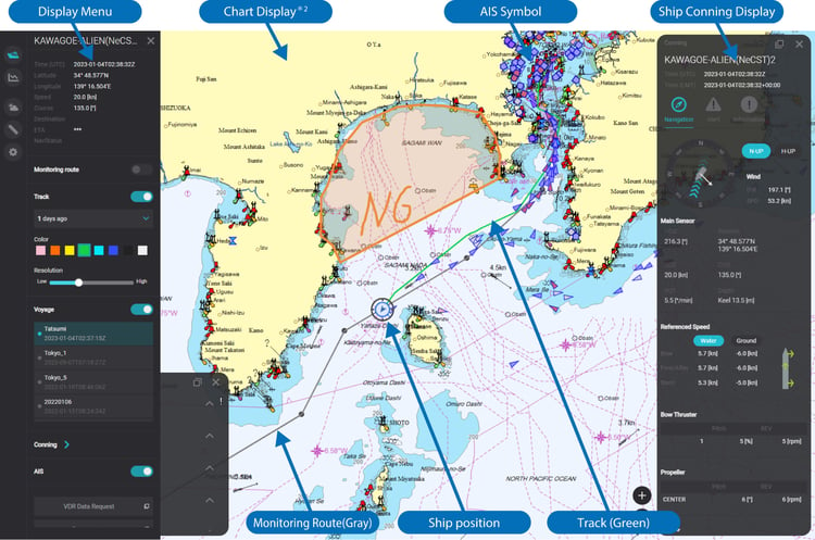
*2 : This chart is not for navigational use. This chart is C-MAP. An optional subscription is required for use.
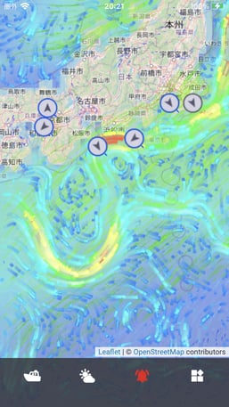
Weather Display
Weather and sea condition information can be displayed together with the managed ships. Wind direction/speed, wave height, currents, surface pressure, and typhoon information can be shown on charts. In addition to the 72-hour weather forecasts, forcasts up to 168 hours can be displayed with an optional contract.
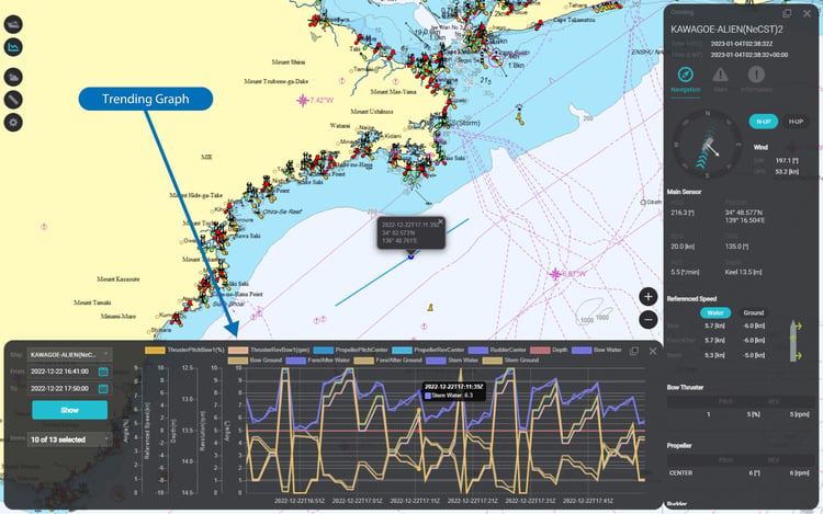
VDR Data Download
For Rapid Situational Awareness in Maritime Accidents
This service allows shore-side retrieval of data accumulated in the onboard VDR/S-VDR*3 (ship speed, steering, various sensor data, radar/ECDIS images, bridge/VHF audio, etc.) via J-Marine Cloud. The downloaded data can be played back directly using SSV. This contributes to confirming vessel navigation status and, in the event of a maritime accident, enables rapid situational assessment without burdening the crew.
This service supports only JCY-1900/1950 and is not compatible with JCY-1800/1850 or third-party VDR/S-VDR units.
*3: This service supports only JCY-1900/1950 and is not compatible with JCY-1800/1850 or third-party VDR/S-VDR units.
VDR / S-VDR Accumulated Data
Radar image records, ECDIS image records, sensor data (AIS, GPS, echo sounder, gyro, speed log, etc.), bridge audio recordings, VHF voice communications
Screen Example

ECDIS [Image Playback Screen]
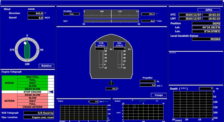
VDR Real Time Monitor [Software Playback Screen]
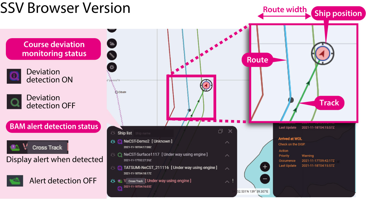
Route Deviation Monitoring
Promptly Detect Route Deviations
by Sharing Information Between Ship and Shore
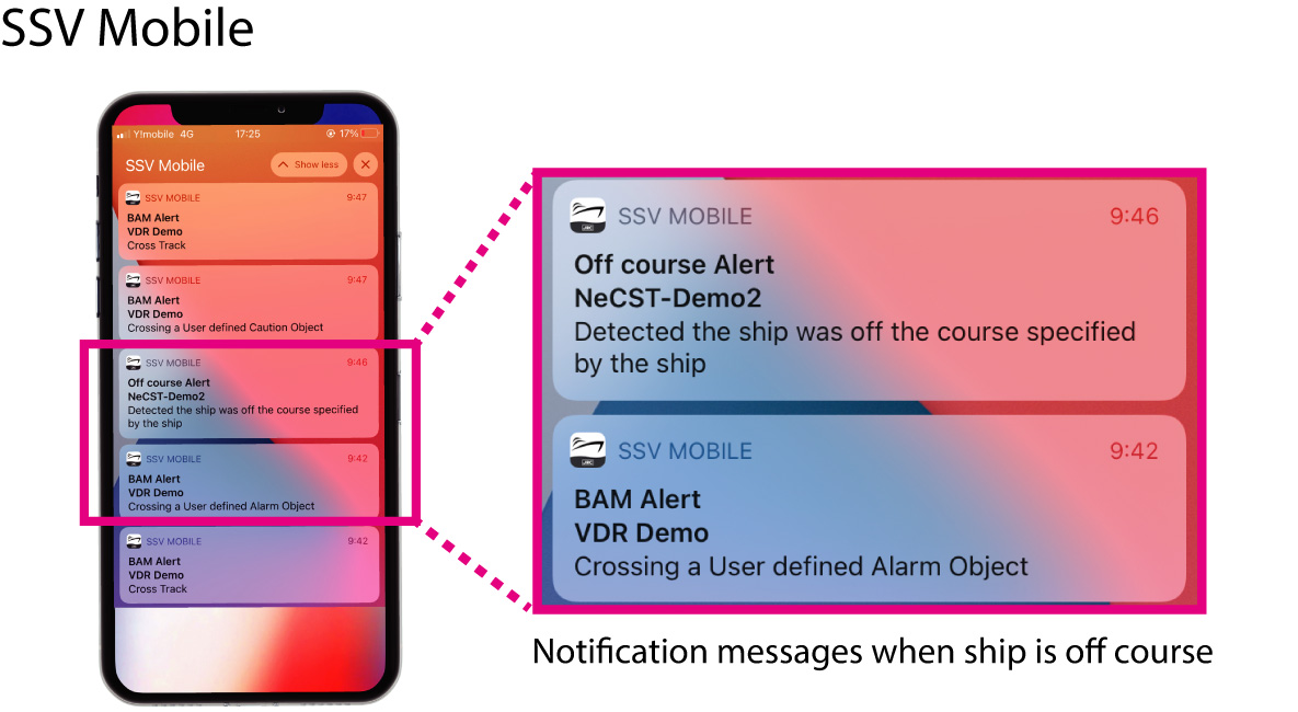
By introducing the route deviation monitoring function*5, alert checking can also be done on the shore side through SSV or SSV Mobile. In case a route deviation alert occurs, promptly contacting the vessel from shore side helps reduce accident risks.
*5 : This service requires installation of internet connection equipment such as Inmarsat FleetXpress or VSAT. The information that can be monitored varies depending on the installed equipment.
System diagram
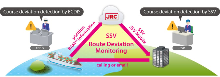
It can be monitored by two route departure monitors.
*6 BAM=Bridge Alert Management
Route Deviation Judgment Methods
There are two methods for judging route deviations, which can be selected according to the purpose. Or you can use both depending on the equipment installed on the vessel.
1) Cloud-based Judgement
In case of strictly monitoring and detecting signs of route deviation
The cloud server calculates whether the vessel's current GPS position uploaded to the cloud has deviated from the route width. Since the route width can be set by the shore operator, signs of route deviation can be strictly monitored and detected.
2) BAM Information-based Judgement
In case of monitoring depth alert and others as well
Route deviation is judged using the route deviation information contained in the BAM (Bridge Alert Management) information. In addition to route deviation, judgements such as navigating in shallow waters can also be made. This allows monitoring the same alert information as occuring on the vessel on shore.
*Supported BAM information : Cross Track, Deviation From Route, Depth Alert, Crossing Safety Contour, Caution Symbol, Alarm Symbol
Display screen in case of the route deviation
Voyage Plan Sharing
Share NeCST Voyage Plans Among Managed Vessels
By accumulating on J-Marine Cloud, voyage plans created in J-Marine NeCST can be shared among the managed vessels. This service reduces the burden of creating voyage plans when multiple vessels are sailing the same route.
This service requires each vessel to have J-Marine NeCST installed.
Image of utilization
The voyage plans created in J-Marine NeCST can be shared among the managed vessels.
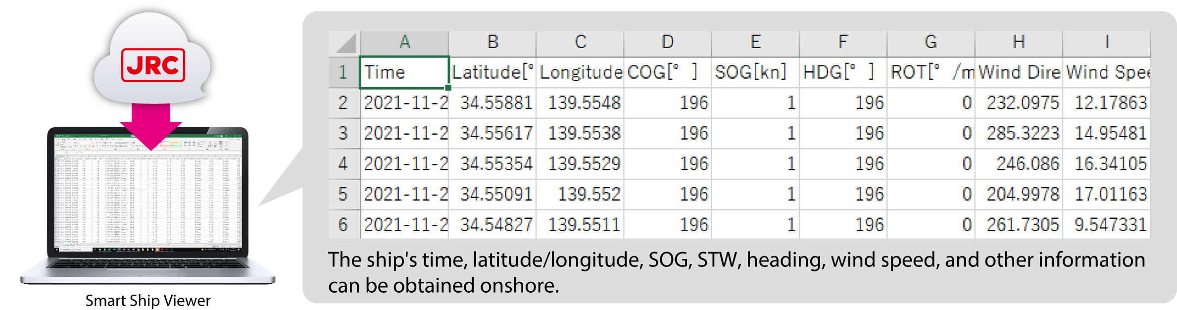
Data Download
Download Vessel Sensor Data in CSV Format
Sensor data accumulated in the cloud for each vessel can be downloaded in CSV format. This function allows for easy analysis of voyage records.
Image of utilization
Measurement
Measure Distances Between Vessel, Coastlines and Other Ships
As map-based vessel management functions, we have implemented three features: "Measuring the distance and bearing between two points on the map", "Measuring the area and perimeter distance of a specified range on the map", and "Measuring distances simulating EBLs and VRMs". By utilizing these functions, shore operators monitoring the vessel can check distances from coastlines and other ships, contributing to predicting dangers.
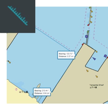
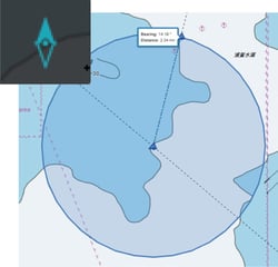
Bearing / Distance Measurement
Measures and displays the bearing and distance between two points on the map.
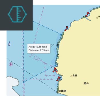
Area / Parameter Measurement
Measures and displays the area and parameter distance of a specified range on the map.
EBL / VRM Measurement
Measures and displays the bearing and distance simulating a radar screen.
System Configuration
Configuration Diagram
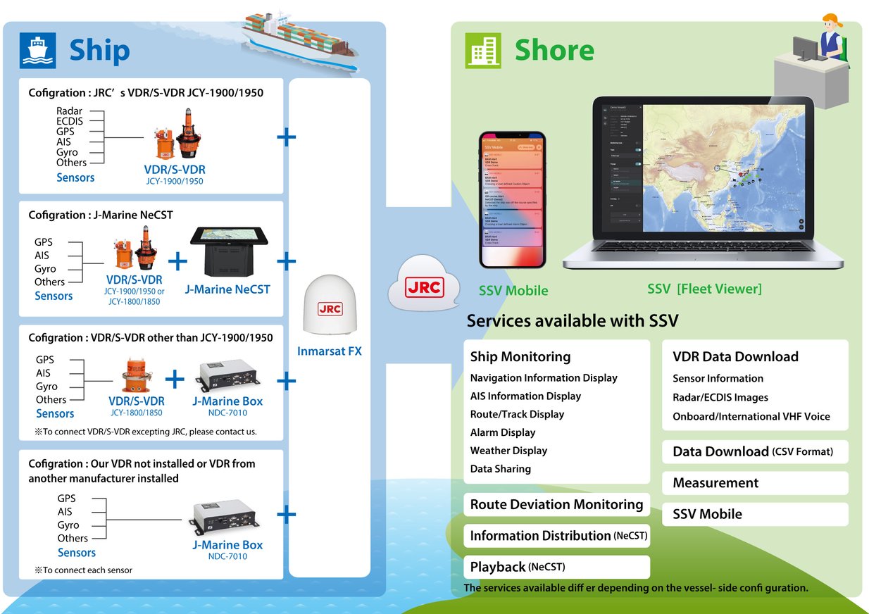
Ship Equipment Configuration
| Model of Implementation 1 | Product Page |
|---|---|
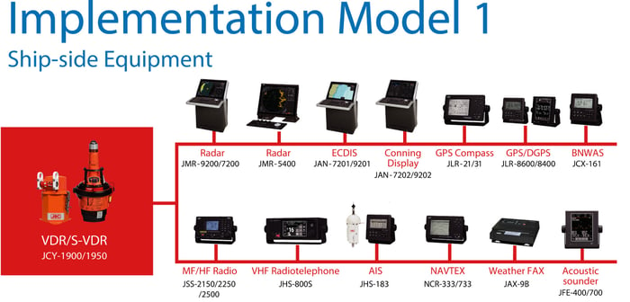
|
|
| Model of Implementation 2 | Product Page |
|---|---|
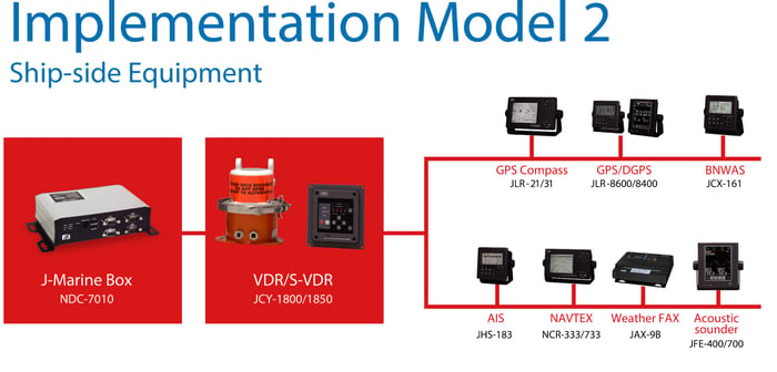
|
|
| Model of Implementation 3 | Product Page |
|---|---|
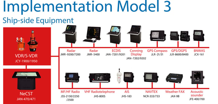
|
|
| Model of Implementation 4 | Product Page |
|---|---|
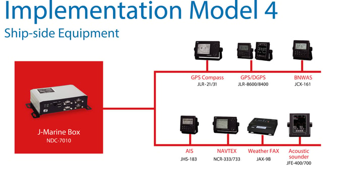
|
*: This service assumes Inmarsat FX or VSAT is installed.
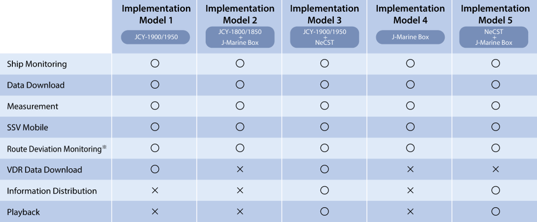
Table of Features by Smart Ship Viewer Implementation Model
The services available on Smart Ship Viewer differ depending on the combination of equipment installed on the managed vessels.
Introducing Our Product
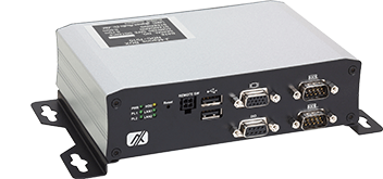
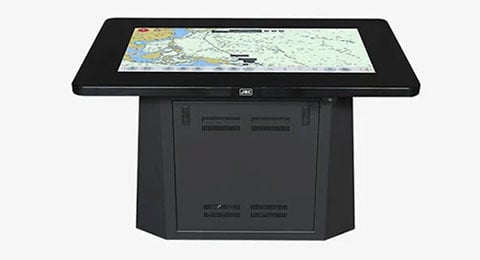
J-Marine BOX
NDC-7010
A equipment for transmiting information from navigational quipment installed on vessels to J-Marine Cloud.
The information accumulated in J-Marine Cloud can be viewed using Smart Ship Viewer.
Mobile Application
SSV Mobile
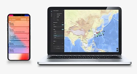
Obtain and Share Vessel Operational Satus and Emergency Information
from Smartphones
It is possible to display a list of the managed vessels on a smartphone. In addition to ship names, routes, and sensor data, you can monitor whether any accidents have occurred and the status of our company's onboard equipment installed on the vessels.
Furthermore, by linking with the Emergency function of the J-Marine NeCST and the chat function, you can promptly detect any emergency situations on the vessel via your smartphone. Early response also becomes possible through chatting directly with the vessel.
Features
- Fleet Viewer: Display all managed vessels on the chart, view routes/tracks/AIS etc.
- Conning : View sensor data and alerts uploaded from managed vessels
- Weather/Sea Conditions: View weather and sea conditions
- Notification History: View alerts and emergency information (including chat) history
Fleet Viewer
Conning
Weather/Sea Conditions
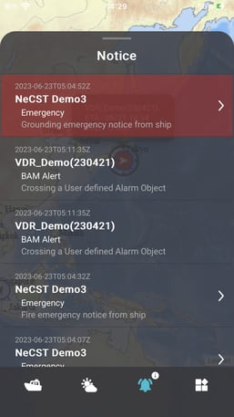
Notification History
Download SSV Mobile App Here

- iOS compatibility: Compatible with iPhone, iPad, and iPod touch with iOS12.0 or newer versions.
- Apple, the Apple logo, iPad, and iPhone are Apple Inc.'s trademarks registered in the United States and elsewhere.
- The iPhone trademark is used under license from AiPhone Co.
- App Store is Apple Inc.'s service mark.
Related Videos
Product Inquiry

Related Products

Product Inquiry
