- Ships DX
- Smart Ship Initiatives
- Shipboard Monitoring
Outline
For today's marine navigation, not only the safety of navigation is required, but also the energy-saving navigation, environmental conservation and anti-piracy measures are called for. For this purpose, ships on voyages need accurate navigational aids from shore bases.
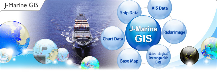
The J-Marine GIS is designed to acquire, manage, analyze and indicate or display a diversity of information including ship status, meteorological/oceanographic and vessel traffic information for ship navigation and operation in an efficient and integrated manner using JRC's original technology.
The J-Marine GIS will cope with various problems in marine navigation to provide appropriate solutions to them, contributing to R&D support, training of personnel, supervision of ship navigation and marine business support.

Features
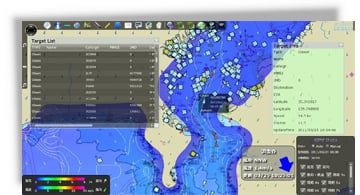
The J-Marine GIS collects various types of information from shore radar stations, AIS stations, ships and meteorological support sites as needed, and stores such information as a database, to which monitors and PCs access to display necessary information.
The J-Marine GIS has been originally developed by JRC to provide overlay display of meteorological/oceanographic information and other various types of information on a chart.
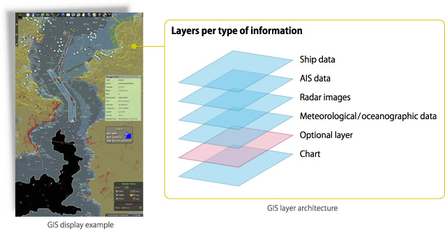
- Overlay display of spatial data and chart
- Selection of various types of data as needed and easy setting of permeability and display order
- Integrated analysis and visualization of various types of data
- Optional layer available by customer’s request
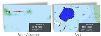
Measuring tools
The measuring tools have the basic functions of the marine GIS, which are capable of measuring routes and distances (lengths) and areas.
System Configuration
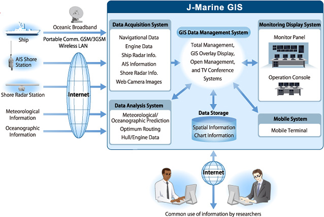
J-Marine GIS provides various types of navigational supervision and business support.
System Applications

Advanced Navigation System
This system is a research system which collects, manages, analyzes and displays a diversity of information on ship navigation and operation in an efficient and integrated manner for supporting the R& D and educational efforts for ship navigation.
VTS/VTMS Integrated Information Management System
This system is an integrated information management system linking with VTS/VTMS systems which are operating individually in different ports or water areas, aiming at safety of marine navigation and efficient operation of port facilities.
Fleet Management System
The system supports the operations such as monitoring of vessel movements, vessel schedule management and crew management of vessels under control by using integrated electronic technology, contributing to precision navigation, energy saving, reduction of CO2 emissions and reduction of fuel consumption as well as environmental conservation.
Workboat Management System
The system supports the operations such as monitoring of workboat movements, management of workboat schedules, crews, materials transportation, work outputs and construction works by using integrated electronic technology.

Oilrig Management System
The system supports the management of facilities, workers and transportation at an oilrig or oil platform by using integrated electronic technology.

Marina Management System
The system supports the management of facilities for boats at a marina, anchorage of boats, information on other marinas and moorings by visitors by using integrated electronic technology.

Fishing Ground/Reef Management System
The system supports the operations such as monitoring of fish school information from fishing boats, management of fishing grounds/reeves based on sensor information including water quality, current drift and set, water temperature and salt concentration, management of monitoring equipment by camera images, and management of vessel fleet fishing through common use of fishing ground information and regulation of illegal operation by using integrated electronic technology.
Advanced Navigation System
![]()
Educational and Research Facility in Maritime Systems
The system is a research system to collect, manage, analyze and display a diversity of information on ship navigation and operations for supporting research and development, and education and training related to ship navigation and operations.
Major Applications
Monitoring of training ship operations/Analysis of vessel movements in port/Optimum Route Simulation/Danger evaluation and verification
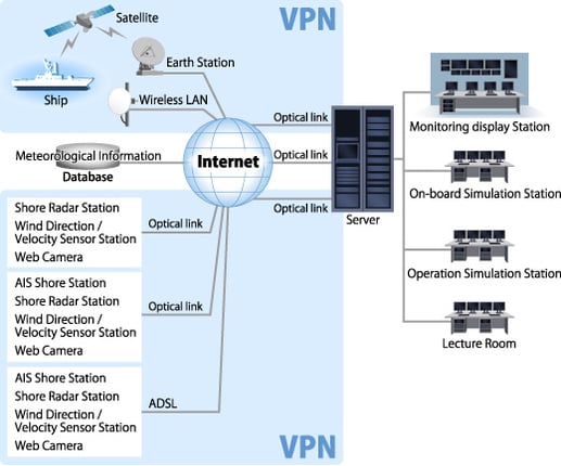
System Image
*The "Advanced Navigation System" is a joint development by Tokyo University of Marine Science and Technology and JRC.
Introduction of the System
This system was introduced by Tokyo University of Marine Science and Technology in March 2011.
Tokyo University of Marine Science and Technology
Introduction of the Advanced Navigation System
Tokyo University of Marine Science and Technology
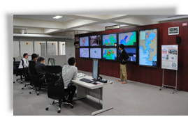
Efficient and Integrated Information Display
Various types of ship-related information are displayed on large monitors.
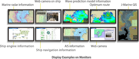
- The system is capable of real-time display to monitor current vessel movements and playback display to reproduce past vessel movements, allowing such displays to be used for monitoring tracks of ships and changes of marine traffic flow in lecture exercises.
- The system is capable of real-time display of radar images, navigational information and engine data via satellite link, allowing navigational experiments to be verified by means of TV conference functions.
- The data from Web cameras installed on ships and shore sites can be used for image processing researches.
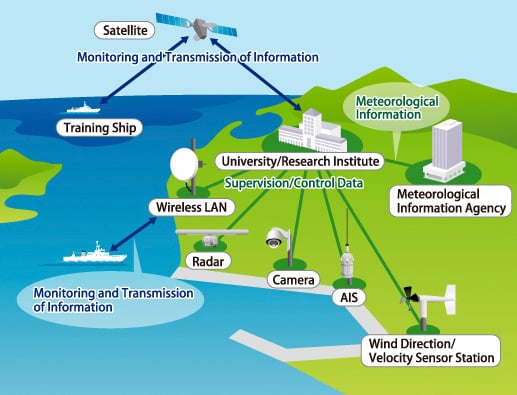
Network Configuration
VTS/VTMS Integrated Information Management System
![]()
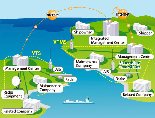
Integrated Information Management System for Marine Use
This system is linked with the VTS/VTMS systems operating in respective ports and straits for safety of navigation and efficient operation of port facilities.
VTS: Vessel Traffic System
VTMS:Vessel Traffic Management System
Major Applications
Monitoring of vessel movements in multiple ports and straits/Danger evaluation and verification/Vessel movements in ports and straits
System Image
Fleet Management System
![]()
System for Supporting the Operation Management of Vessels under Control
This system supports the management of vessel operations including monitoring of vessel movements, schedule management and crew management of vessels under control using integrated electronic technology, contributing to precision navigation, energy saving, reduction of CO2 emissions, reduction of fuel consumption and environmental conservation.
Major Applications
Monitoring of vessel under control/Support of optimum precision navigation/Spport of cargo handling management/Spport of crew management/Maintenance and troubleshooting management
System Image
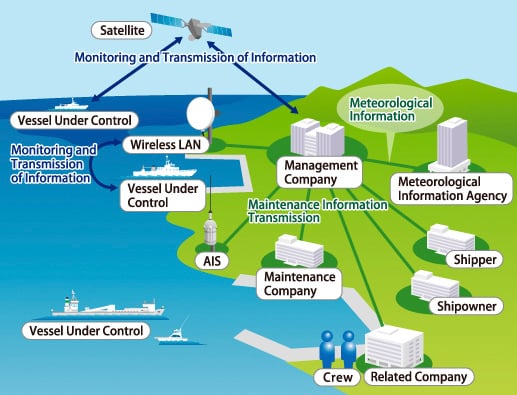
*Vessels under control are managed by management company and covered by the surveillance coverage of shore radar and AIS shore stations.
Workboat Management System
![]()
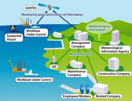
System for Supporting Workboat Operation Management
This system supports the management of workboat operations including monitoring of workboat movements and management of work schedules, crews and material transportation, work outputs and construction works by using integrated electronic technology.
Major Applications
Monitoring of workboat movements/Remote monitoring of work status/Support of materials management/Spport of workers management/Troubleshooting management
System Image
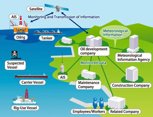
Oilrig Management System
![]()
System for Supporting Oilrig Operation Management
This system supports the management of oilrig or oil platform operations including the management of equipment, workers and transportation by using integrated electronic technology.
Major Applications
Monitoring of operatinal status of equipment/Remote monitoring of production outputs Support of materials management/Spport of workers management/Troubleshooting management
System Image
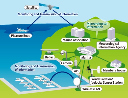
Marina Management System
![]()
System for Supporting Marina Operation Management
This system supports the management of marina operations including the management of boat-related facilities, anchorage, other marina information, visitors’ mooring at a marina by using integrated electronic technology.
Major Applications
Monitoring of boat movements/Anti-theft management/Support of charging management Spport of membership management/Troubleshooting management
System Image
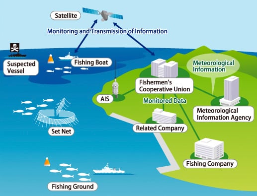
Fishing Ground/Reef Management System
![]()
System for Monitoring Fishing Grounds/Reeves and Supporting Fishing Operations
By using integrated electronic technology, the system supports the monitoring and management of fishing grounds and reeves based on fish school information on fishing boats and sensor information including water quality, drift and set, water temperature and salt concentration, and the management of monitoring equipment on camera images and fleet fishing operations and illegal fishing operations through common use of fishing ground information.
Major Applications
Monitoring of fish school movements/Fishing ground/reef management/Monitoring of water quality, drift and set/Common use of fishing boat sonar/Analysis of meteorological/oceanographic information Support of landing fishes/Remote operation of monitoring cameras
System Image
Product Inquiry

Product Inquiry

