- GPS/GNSS Compass

Features

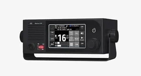
Display Unit
The new GNSS Compass JLR-41 is a heading sensor that uses GNSS (Global Navigation Satellite System) to determine the ship‘s heading. The Sensor is more accurate and smaller than our previous JLR-21 sensor.

Sensor
Multi-GNSS Sensor
The newly designed multi-GNSS sensor can simultaneously receive GPS, Galileo, GLONASS, BeiDou, and QZSS data, enabling highly accurate positioning without the use of beacons or SBAS, thereby ehhancing orientation performance.
Spoofing/jamming Detection Function
JLR-41 is equipped with a spoofing/jamming countermeasure function*3. When spoofing/jamming is detected, users are notified via pop-up, icon, and buzzer. Furthermore, satellite signals affected by spoofing/jamming are excluded to maintain accurate positioning*4. This contributes to safe and secure navigation
Furthermore, SSV can be used to monitor spoofing/jamming occurrence status from shore.
For more information about SSV, please click here.
*3: A separate license is required to enable the spoofing/jamming detection function.
*4: If few satellites are unaffected by spoofing/jamming, positioning may not be possible.

Supports Rolling, Pitching, Rate of Turn and Heaving Measurements
Heaving measurement relatively measures the vertical displacement of the ship caused by waves and swells.
Rolling and pitching measurements are used to measure the ship's lateral and longitudinal movements.
By inputting the measurement data into fish finder or other device equipped with stabilizer function, the detection accuracy of fish schools and seabed topography can be improved.
The rate of turn (ROT) has a maximum follow-up angular velocity of 45°per second, enabling stable tracking even during high-speed turns.
 Ship's heading, heaving, roll, pitch, ROT
 Heel (Roll) screen
IMO type-approved Transmitting Heading Device (THD) and Satellite Positioning System (GPS)
The new GNSS compass JLR-41 complies with IMO performance standards as both a THD and GPS. It can be equipped as a THD or GPS that meets the installation requirements of SOLAS-V.

Heel (Roll) Screen
(Not yet certified)
6.5-inch Large Color LCD
The new GNSS Compass JLR-41 combined with our trusted 6.5-inch color touch panel display will providing you with the comfort of an intuitive operational approach.
- Provided with many graphic display modes
- Improve operability by touch panel and abundant menus
System Diagram

Dimensions

Sensor JLR-4101
Mass: Approx. 5.3 kg (11.67 lbs)

Display Unit NWZ-1680
Mass: Approx. 1.8 kg (3.97 lbs)
*including Base Kits
Specs
Sensor JLR-4101
| Receiver System | GPS / Galileo / GLONASS / BeiDou / QZSS |
| Receiver Type | GPS+QZSS: 15 ch SBAS: 1 ch Galileo + GLONASS or Galileo + BeiDou: 10 ch |
| Receiving Frequency | 1575.42 MHz (GPS / Galileo / SBAS / QZSS) 1598.063 - 1605.375 MHz (GLONASS) 1561.098 MHz (BeiDou) |
| Course Accuracy | 0.25° RMS |
| Attitude Accuracy (Roll) | 0.4° RMS |
| Attitude Accuracy (Pitch) | 0.4° RMS |
| Attitude Accuracy (Heaving) | 5 cm RMS |
| Course Resolution | 0.1° / 0.01° |
| Speed Resolution | 0.1 kn / 0.01 kn |
| Attitude Resolution | 0.1° |
| Tracking Rate of Turn | 45°/sec |
| Start-up Time | Less than 2 minutes (warm start fix, typically 30 seconds) |
| SBAS Receiver | WAAS, MSAS, EGNOS |
| Positional Accuracy | Multi-GNSS (PPP positioning) : 1.8 m (2DRMS) (HDOP ≦ 4 SA OFF) Multi-GNSS (non-PPP positioning) : 4 m (2DRMS) DGPS : 4 m (2DRMS) SBAS : 4 m (2DRMS) GPS or GPS + QZSS : 5 m (2DRMS) GLONASS : 10 m (2DRMS) Galileo : 6 m (2DRMS) BeiDou : 10 m (2DRMS) |
| Spoofing/Jamming | Can be detected (license require) |
Display NWZ-1680
| Display Unit | 6.5-inch TFT color touch panel LCD, 640x480 dots (VGA) / Brightness: 800 cd/m² |
| Display Modes | Heading, navigation information, plot, analog, highway, satellite information, waypoint information, beacon text, navigation aid |
| Power | 12/24 VDC ( +30 %, -10 % ) |
| Power Consumption | Less than 14 W ( including sensor ) |
Interface
| Port | IEC 61162-1 : (input) 1 port, (output) 2 ports IEC 61162-2 : (output) 1 port LAN (IEC 61162-450) : 1 port Sensor through (IEC 61162-1) : (output) 2 ports Dry contact: (input) 1 port, (output) 3 ports |
| NMEA 0183 Version | Ver1.5 / 2.1 / 2.3 / 4.0 |
| NMEA 0183 Input Sentence | ACK, ACN, DDC, HBT, POS |
| NMEA 0183 Output Sentence | AGL, ALC, ALF, ALR, ARC, DDC, DTM, GBS, GGA, GLL, GNS, GRS, GSA, GST, GSV, HBT, HDT, HRM, MSS, RMC, POS, ROT, THS, VTG, ZDA |
Environmental Conditions
| Operating Temperature | Sensor : -25 to +55 ℃ , Display Unit : -15 to +55 ℃ |
| Storage Temperature | Sensor : -25 to +70 ℃ , Display Unit : -25 to +70 ℃ |
| Degree of Protection | Sensor : IP56, Display Unit : IP56 |
Components
Standard Components
| Name | Model | Qty |
|---|---|---|
| Sensor | JLR-4101 | ×1 |
| Display Unit | NWZ-1680 | ×1 |
| Power Cable | CFQ-5770A | ×1 |
| Data Cable | CFQ-7248 | ×1 |
| Data Cable | CFQ-5771B | ×1 |
| Instruction Manual | English : P00011567 | ×1 |
| Bridge Card | English : P00022759 | ×1 |
Option
| Name | Model |
|---|---|
| Data Cable (30 m) | CFQ7248-30 |
| Extension Cable (10 m) | CFQ7249-10 |
| Extension Cable (20 m) | CFQ-7249 |
| Junction Box | NQE-7720 |
| Beacon Connecting Cable | CFQ-7250 |
| Installation Trestle | P00004089 |
| Bird Repellent Rod | P00015258 |
| Power Cable | CFQ-5770D |
| Data Cable (10 m) | CQQ-5771D |
| Ethernet Cable (15 m) | CFQ-7540 |
| Base Kits | MPBX50347 |
| Select Switch | NCZ-777 |
| Select Switch | NCZ-1537B |
| Junction Box | CQD-10 |
| Output Buffer | NQA-4351 |
| Printer | NKG-104 |
| Printer | RP-D10 |
| External Dimmer Unit | NCM-227 |
| AC/DC Power Supply Unit | NBD-904 |
| Conversion Cable | P00014414 |
Product Inquiry

Related Products
VHF radio and UHF onboard communications
Product Inquiry
