J-Marine GIS

Introduction of Implementation Customer

It is a great progress that the movements and surrounding status of our own ship can be monitored in real time.

Company Name

Ube Shipping & Logistics, Ltd.

Location of Main Office

5-5, Minato-machi 1-chome, Yamaguchi Prefecture

Items of Business

Coastal shipping service, Port shipping service, International multimodal transport service, Container business, Engineering business Industrial waste disposal business, Shipping agency Machinery and equipment installation works (construction works) Others

Pre-implementation Tasks

Before introduction of it, it had taken much time to monitor the movements of our own ships.

Pre-implementation Tasks

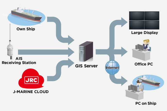
Before the integration of the J-Marine GIS with the AIS information has been established in our company, we monitored and grasped the position information on our own ships by automatically transmitting the signals of the GPS carried on each ship in the intervals of one hour.
However, this information could define the positions of those ships, but it was impossible to make clear the surrounding conditions (for example, such as other ships in the vicinity, and meteorological and oceanographic conditions). Also, there was no playback capability for verification of accidents.

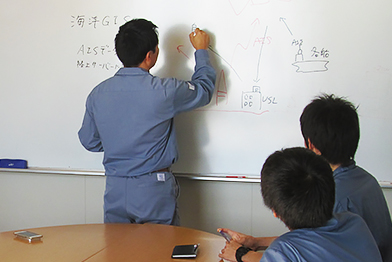
The background of introducing the J-Marine GIS was based on our concept that our company should embody the future vessel management system based on our participation in the study of advance navigation with Tokyo University of Marine Science and Technology.

Implementation Issues and Resolution Procedures

The J-Marine GIS contributes to Safety of Navigation, Energy Efficiency and Verification of Accidents.

Implementation Issues and Resolution Procedures

It is a significant advance that the movements and the surrounding conditions of our own ships can be monitored in real time by introduction of the J-Marine GIS, At present, not only the AIS information automatically transmitted from each ship but also the weather and oceanographic information can be presented simultaneously, contributing to safety of navigation and energy efficiency.

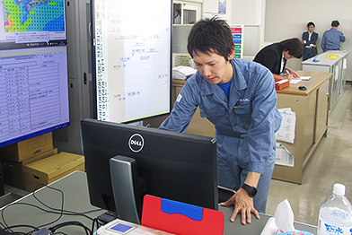
In the early stage of introduction, the GIS had been monitored by some personnel in our company, but our company provided the information service not only within our company but also expanded it to other associated shipping companies by distribution through our Web server. Since the introduction of the J-Marine GIS, several accident cases of ships related to our company have occurred. The system has served for analysis and verification of the accidents. It is also the good effect of introducing the J-Marine GIS that the records of accidents can be saved and replayed.
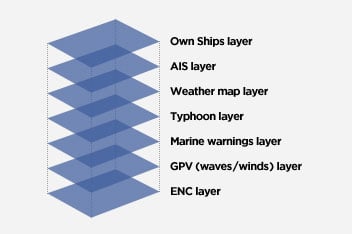
Overview of Implementation System

J-Marine GIS - Introduction of the System of Ube Shipping & Logistics

System Configuration

This system is designed to collect the AIS data received by the AIS receiving shore station and the own ships and to monitor the movements of the ships in the Ube Port and in the surrounding of the own ships. The AIS information, own ships, and weather and oceanographic information are superimposed on the electronic navigational chart (ENC), serving to grasp the movements of the own ships and the surrounding conditions, and to support the safety of navigation.

System Configuration

Feature 1. Web-GIS Functions

The Web-GIS system is adopted for display. The information on the own ships, AIS information, weather and oceanographic information and other various types of information are superimposed on the ENC.
Spatial data is superimposed on a chart.
Various types of data are selectable for the purposes and the transmittance rate and the order are settable.
Analytical results can be visually presented by combinations of various types of data.
Necessary information can be provided to ships and associated companies via Internet.

GIS Layer Structure

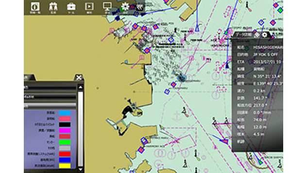
AIS information display
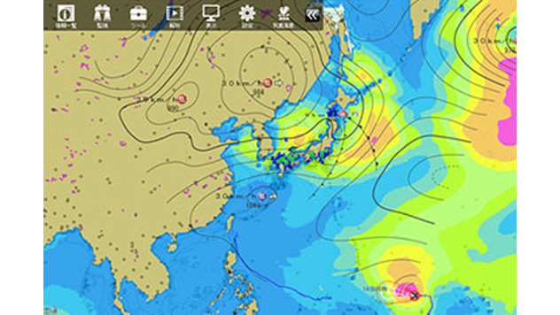
Weather/
oceanographic information display

Playback reproduction

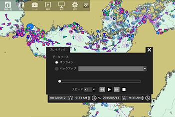
Feature 2. Playback Function

The past movements of ships can be reproduced by playback function.
The tracks of ships and weather/oceanographic conditions can be monitored and used effectively for analysis and verification of accidental causes in event of sea accidents.

Introduction of Fleet Cloud Vessel Management System

“Fleet Cloud” is the collective name of the vessel management systems that are used by our own and other vessel management company and associated companies.

  • Vessel’s Costs/Procurement Management
    The procurement of repair parts and general consumables and the budget and results management are made.
  • Assignments of Vessels
    The vessel operation information is shared by both the ship side and the company side.
  • Berthing Schedule
    The operating status (including the leaving time of the former ship and the berthing wharf and time of own ship) of the wharves of the major loading ports such as Ube and Kanda is managed. (The berthing schedule is always displayed on a large-type monitor in the company office.)
  • History of Works
    The major accidents that have occurred and the special works that have been executed are built as the database, allowing the recurrences of similar accidents to be prevented and the immediate response to such accidents and works to be made.
  • Operation Performance
    The monthly summary is automatically prepared based on the abstract log data that is transmitted from each vessel. (The automatic sum-up data includes navigational performance, fuel consumptions and operating efficiency.)
  • Engine Data Import
    The engine data logger information that is automatically transmitted from the vessel side to the Cloud side on a regular base is imported in the system to indicate in the forms of text and graph for grasping the trend of engine operation status.
  • Check List of Freon Equipment
    The list is prepared to meet the revised Freon Handling Regulations.

Implementation Product System

J-Marine GIS Ships Real Time Monitoring System

Ships real Time Monitoring System is to collect AIS Information, Radar Information and Ocean Weather Forecast information and available monitoring such information by Web Browser on PC real-time. Those several information can be displayed in multi layer by J-Marine GIS.
* The contents of this implementation example are current as of April 2016.

Contact Us

Inquiries by web form

Contact Us