- ECDIS
Provide a smooth operating environment ensured by high-speed chart drawing.
- Conforming to the latest IMO performance standards with Marine Equipment Directive(MED) certification.
- Ensuring intuitive and easy-to-use display and operation performance reflecting professional user's voices.
- Integrating route editing and route safety checking to support safer route plans.
- ECDIS type-specific training (TST) is provided by a variety of organizations around the world on behalf of JRC.
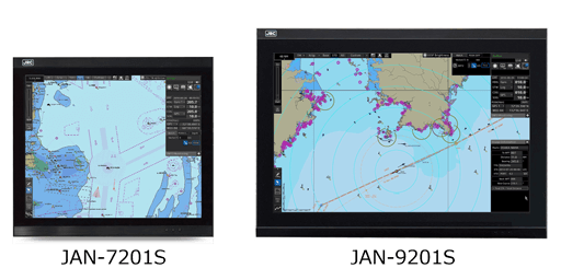
- Selectable screen size, 19-inch (SXGA) or 26-inch (WUXGA) as customer's choice.

ECDIS
The Electronic Chart Display and Information System (ECDIS) is a geographic information system for voyage planning and route monitoring to support the safety navigation of ships at sea. And in response to the latest revision of the International Convention for the Safety of Life at Sea (SOLAS), the International Maritime Organization (IMO) enforced the mandatory installation of the ECDIS by July 2017 according to vessel's category.(Requirements for the equipment and operation qualification are subject to approval from the country with which the ship is registered and recommendations from the classification society of the ship.)
The ECDIS onboard a ship uses information from the automatic identification system (AIS) and superposes the images with navigational chart information, thus accurately displaying dynamic information on other ships around. Also the ECDIS plays central roles in the safe navigation of the ship and provides safety functions, including the generation of warnings when the ship approaches dangerous areas. The ECDIS is useful for marine accident avoidance and serves as equipment indispensable to the safe navigation of ships.
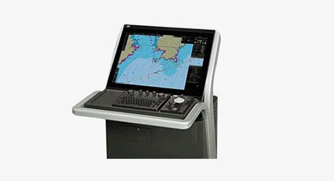
Sophisticated user interface
Sophisticated user interface
The ECDIS JAN-7201S/9201S incorporates a new user interface (named jGUI) for an intuitive, easy-to-use, simple menu system based on the display of icons. This interface always displays critical data in fixed positions on the screen while icon-based menu display informs users of corresponding functions straightaway. Furthermore,target tracking (TT) and AIS symbols feature pop-up displays while mouseover on the target showing their main data at a glance.
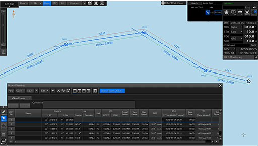
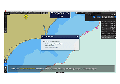
Route editing screen example
Route editing and safety checking
JRC's new ECDIS JAN 7201S/9201S has integrated route editing, which was conventionally divided into two segments, i.e., graphics input and numeric table input areas, into one.
Waypoints, if specified, on a navigational chart are immediately quantified and added to the numeric editing table, and the numeric data on the waypoints that is input into the editing table is immediately reflected on the navigational chart.
Up to four routes can be edited at the same time, and a portion cut out of any route can be combined and the routes can be all or partly replaced or edited.
Furthermore, a safety check on edited route data is possible with a click of a button.
Detected error information items, if any, are listed and displayed, and the corresponding route portions are highlighted in the chart and table, which can be confirmed at a glance to take remedial measures.
Regulations and major specifications
This equipment conforms to the requirements set out in the IMO's resolution MSC.191 (79) for display-related voyage information adopted in December 2004 and the IMO Resolution MSC.232 (82) for ECDIS performance standards adopted in December 2006.
Other specifications of the ECDIS are shown below.
- Electronic chart display function : IEC 61174
- Display-related voyage information : IEC 62288
Operation
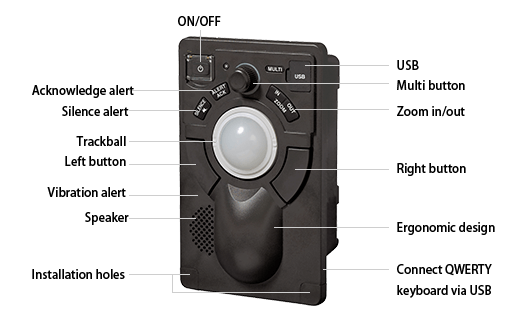
Easy-to-use operating unit
The newly designed trackball supports all the operation of the equipment. Users will be alerted with alarms from the operating unit and color changes under situations that require attention.
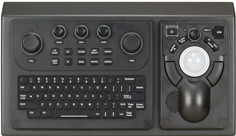
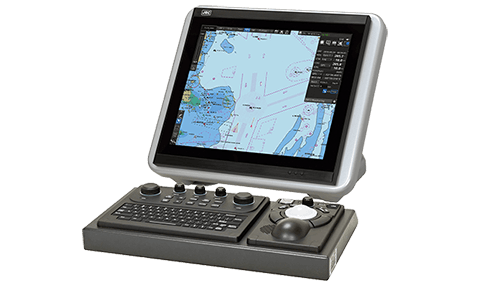
Operation unit with optional keybord
Optional keyboard
The ECDIS will be operable like conventional models by connecting an optional operating unit that incorporates dedicated function buttons, control knobs and a full keyboard adopting the QWERTY layout.
Selectable screen sizes
A newly designed narrow-frame 19-inch (SXGA) and 26-inch (WUXGA) LCD monitors are prepared for the ECDIS JAN-7201S/9201S. Each monitor adopts an LED backlight, thus providing high-quality images that are highly visible both during the day and at night.
Correspond to the major chart
The ECDIS JAN-7201S/9201S supports the display of major electronic navigational charts (ENCs), including those provided by ADMIRALTY Vector Chart Service (AVCS) (S-57 Ed 3.0/3.1 and S-63), NAVTOR ENC Service, and Jeppesen ENC Service as well as ADMIRALTY Raster Chart Service (ARCS). Also, it supports advanced features provided with ENCs, such as the Admiralty Information Overlay (AIO) of AVCS by the United Kingdom Hydrographic Office (UKHO) and Dynamic Licensing of Jeppesen ENC service.
ENC (S-57 and S-63 vector charts)
- AVCS (AIO supported)
- NAVTOR ENC Service (PAYS supported)
- Jeppesen ENC Service
- (Dynamic Licensing supported)
Raster charts
- ARCS
Others (private charts)
- Jeppesen Ed.3 Professional
- Jeppesen Ed.3 Professional+
Type-specific training (TST)
Unlike JRC's conventional ECDIS models, this ECDIS has adopted a new operation system and a TST program supporting the new operation system is required. The TST for the new ECDIS is given at JRC's major branches, agents, and training institutions around the world. The training will be given onboard or offices by instructors dispatched at the request of customers. Furthermore, PC software is available for users' self-learning at home or onboard. For more information about TST, contact your JRC representative.
System
Block diagram
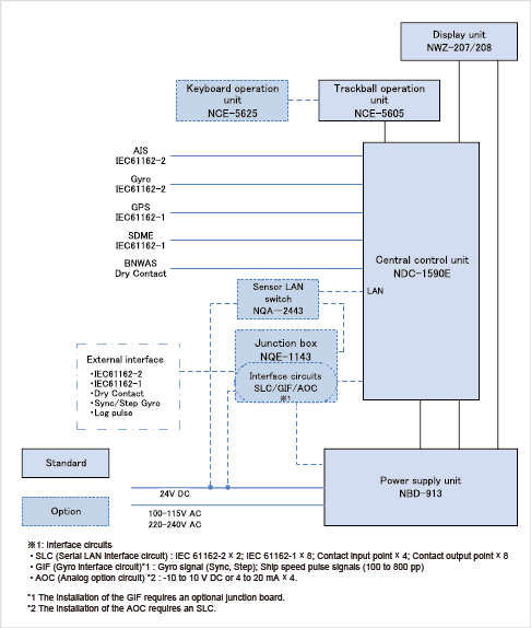
In the box
- Central control unit
- Power supply unit
- Display unit
- Trackball operation unit
Options
- Keyboard operation unit
- Sensor LAN switch
- Junction box
- Serial LAN interface circuit(SLC)
- Gyro interface circuit (GIF)*1
- Analog option circuit (AOC)*2
*1 The installation of the GIF requires an optional junction board.
*2 The installation of the AOC requires an SLC.
Dimension
19-inch monitor and desktop frame*
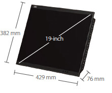
NWZ-207 Weight :6 kg
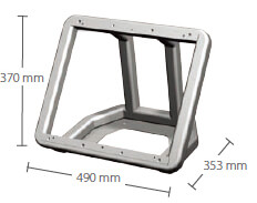
CWB-1594 Weight: 3.6kg
26-inch monitor and desktop frame*
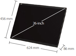
NWZ-208 Weight: 16 kg
CBW-1595 Weight: 5.5 kg
Central control unit
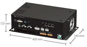
NDC-1590E Weight: 5.6 kg
Power supply unit
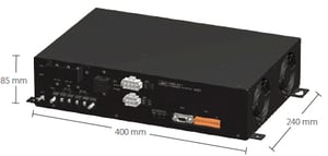
NBD-913 Weight: 4.2 kg
Trackball operation unit
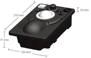
NCE-5605 Weight: 1.3 kg
Keyboard operation unit (option)
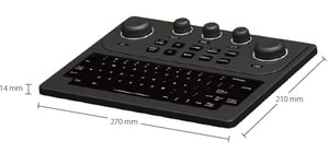
NCE-5625 Weight: 0.8 kg
Junction box (option)
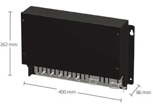
NQE-1143 Weight: 3.8 kg
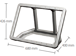
Operation unit desktop frame and large tray*
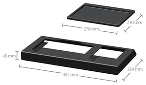
CWB-1596 Weight: 1 kg
CBW-1593 Weight: 0.3kg
*Operation unit desktop frame and large tray are option.
Specs
| Model | 19-inch model | JAN-7201S |
|---|---|---|
| 26-inch model | JAN-9201S | |
| Conforming to IMO standards | ✓ | |
| Hardware function | ||
| Display unit | JAN-7201S: 19-inch SXGA color LCD, 1280 × 1024 pixels JAN-9201S: 26-inch WUXGA color LCD, 1920 × 1200 pixels |
|
| Central control block | Intel Core i5 2515E 2.5GHz 2GB main memory SSD × 2 DVD drive × 1 |
|
| Power supply | 24V DC and single-phase 100 to 115V AC or 220 to 240 V AC at 50/60 Hz | |
| Power consumption | Rating JAN-7201S: 200 VA approx., JAN-9201S: 240 VA approx. | |
| Chart display function | ||
| Chart database | ENC: S-57 Ed3.0/3.1 and S-63 AVCS (AIO supported), NAVTOR ENC Service, Jeppesen ENC Service Raster charts: ARCS Personal chart: Jeppesen Ed.3 Professional / Professional+ |
|
| Operation mode | TM (true motion)/RM (relative motion) display | |
| Azimuth display mode | True motion mode: North UP/Course UP/Head UP/Waypoint UP Relative motion mode: North UP/Course UP/Head UP/Waypoint UP |
|
| Scale | 1:1,000 to 1:40,000,000 (SXGA) / 1:20,000,000 (WUXGA) | |
| Range | 0.125, 0.25, 0.5, 0.75, 1.5, 3, 6, 12, 24, 48, 96NM | |
| Multi-window display | Upper-lower split / Left-right split / Picture-in-picture | |
| Route planning function | ||
| Route creation | Table/Graphic editing | |
| Route editing | Waypoint addition / deletion / edition Alternative route creation Route copy Connection between routes Import / export (in CSV) |
|
| Safety check | Yes | |
| Number of routes displayed | Four types max. | |
| Navigation-monitoring function | ||
| Own ship | Monitoring for position, wake, and dragging anchor | |
| Route monitoring | Water depths, obstacles, approaching prohibited areas, course deviation, waypoints, and arrival time | |
| Other ship monitoring | AIS display: 500 targets max. | |
| User map | ||
| Number of display points | 100,000 points (marks and lines) | |
| Import/Export | Possible with USB memory | |
| Other functions | ||
| Data display function | Conning data block display | |
| Self-diagnostic function | Standard | |
| Remote maintenance function | Standard | |
| Playback | Navigation data (3 months max.) Logbook (3 months max.) |
|
ECDIS Software version / Type approval status
More details can be found here "ECDIS Software version / Type approval status"
All specifications are subject to change without notification.
Product Inquiry

Related Products
Product Inquiry

